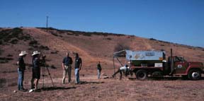
The Faultline Crew broadcasts live as blasting
agents are loaded into a well.
Click on the image to enlarge it.
Listening to the Earth
Interstate Highway 5, or as they say in LA, "The five," crosses the San Gabriel Mountains, through a gap, Tejon Pass, carved by erosion through rocks that have been pulverized by the motion of the Sam Andreas fault. So while Angelinos fear the fault and its cousins for the destruction it could bring to their city, they also thank it for providing them with an easy path through the mountains.
Ellen and I began the day just east of "the five" by driving our full size van, Horace, up a rough dirt road along the top of a remote ridge between Boquet and San Francisquito canyons, in the Angeles National Forest. We were a part of the Exploratorium's Faultline Project, following the San Andreas fault from south to north and reporting on the scientists who were studying the fault. Today, we were going to meet scientists who were setting off explosions underground. We were searching for a truckload of explosives, and we found it. The truck was a part of LARSE, the Los Angeles Regional Seismic Experiment. The boy inside me was thrilled, I got to work outside for the day, near explosives, wow!
We were met at a locked gate by Gary Fuis a USGS geologist with a ready smile. Minutes after meeting him Ellen handed him a rock, Ellen loves rocks. So does Gary, he turned it over in his hand, licked it to make it wet so that he could see its structure better and said" it's a conglomerate rock," notice this pebble of granite in the whitish matrix. He smiled and handed the rock back to Ellen. I told him I was a physicist interested in geology, he replied that he was a geologist interested in physics! This was going to be a fun day.
Gary lead us up the twisting dirt roads and through locked gates. As we turned a corner in the barren brown landscape we came upon a truck sporting an diamond shaped orange placard warning "Blasting Agents 1.5 d." A blue hose snaked from the back of the truck down into a foot diameter pipe that disappeared into the ground. three men were standing around the pipe: Gordon was the explosive expert, he looked the role, with a white hardhat and dark glasses, he looked like he was in charge here. JW was the truck driver who wanted to learn more about blasting, he wore a blue hardhat and matching coveralls, and Luke, who was a recent college graduate geologist in a USGS T-shirt with a clipboard writing down all the details of the blasting agent loading operation. We always teach laboratory students to write down details of their experiment, and here was Luke, in the field doing exactly that, recording every detail of the operation.
The Faultline Crew broadcasts live as blasting
agents are loaded into a well.
Click on the image to enlarge it.
Gordon quickly set me straight about explosives and blasting agents. The blasting agents that they were loading are extremely difficult to set off. A mixture of ammonium nitrate and fuel oil, they can burn without exploding. That's why the placard on the truck did not say "explosives."
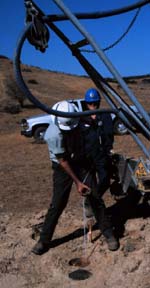
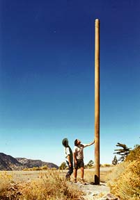
The hole they were standing around had been drilled months ago. Gordon first probed its depth by lowering a metal weight attached to a measuring cord. I was slightly depressed to see that the cord was marked in feet and inches.
Gordon, the Blasting expert , measures
the depth of a well by lowering a lead weight at the bottom
of a measuring tape while JW looks on. The well is 8 inches across, 20 cm, and
is lined with a steel pipe. It is 80 feet, or 27m, deep.
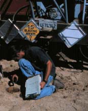
Luke used a pocket mirror to reflect sunlight down into the hole,
sunlight is better than any flashlight, it brightly illuminated the
steel-cased hole and allowed me to see water at the bottom. We often
do an acivity in high school physics in which students reflect light
off a mirror, here the same tools were being used in the
field.
Luke, a young geologist working for the
USGS, inspects the well by using a pocket mirror to reflect
sunlight down it. The steel case of the well curves gently
downward until it disappears into water. He notes that using a mirror to reflect
sunlight is better than any flashlight.
By pulling up the weight until it came free of the bottom they could measure that the water filled the hole to within 40 feet (13 m) of the surface. The water was good, it would save them a lot of work. They needed to cover the blasting agents with something to tamp the explosion, to keep it down in the earth, if the hole wasn't full of water they would have to shovel it full of dirt. They then cut off a 90 foot length of detonator cord and used duct tape to attach one end to a rock. They used duct tape again to attach three "cast boosters" to the detonator cord about 10 feet apart, these were cylinders about 6 inches long and 1 inch in diameter (15 cm long 2.5 cm radius.) and exploded like the detonator cord. The boosters gave the extra explosion necessary to set off the blasting agents. The final step was lowering the bottom of the cord down into the well. They carefully tied the upper end of the cord to the large metal cap. Gary said that the worst thing that could happen was to lose the upper end of the cord down the hole, it is impossible to fish out again!
JW unspooled a blue hose from the back of the truck and poured the blasting agent down into the well. He carefully measured the amount, 500 pounds, or 220 kg. The blasting agent is heavier than water and so settled down to the bottom of the well.They then locked the metal cap onto the top of the well and covered it with dirt to keep passersby from finding it and messing with it.
In a week the blasting crew would come in the middle of the night. Try to find each hidden well in the dark. Hook up an electrical detonator to the blasting cord, back off 300 feet, 10m, and set off the explosives.
Before. After.
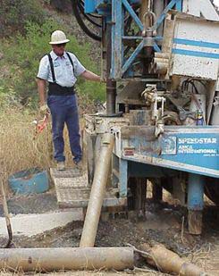
A drill rig bores an 8 inch, 20 cm, diameter hole 80 ft.
,27m , deep then lines it with a steel casing. A spare drill
bit is in the bottom right corner.
The explosion blasts the steel casing of the well 30 feet,
10m, into the air.
We drove on from the first blast hole to the second. Along the way we passed red ribbons tied to shrubs. Gary said that they marked seismometers. We were driving from seismometer to seismometer at about 15 miles an hour, after each explosion, the seismic waves would race out faster than 7,200 miles an hour (3 km/s). Just like ultrasound can be used to image a fetus or a heart inside a body, the seismic waves from the explosion would make an image of the underlying bedrock of the Los Angeles Basin. It was a good thing that Gary liked physics, because the process of converting the arrival times of the sound into an image of the earth takes a lot of calculation. He said that it would take years to analyze the data they would gather from this series of experiments.
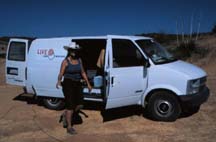
The white Exploratorium "Live@" minivan was parked next to the second well. Sabrina and Jason welcomed us, then returned to making a satellite connection. We were going to broadcast the process of filling a well with blasting agents live over the web. Zane Vella the producer of this program was a pioneer in the techniques of webcasting from the field, we had a bare bones setup: a digital camera, a Tandberg deck designed for video conferencing (picture phones!) and an INMARSAT satellite transceiver. With this rig we could send and receive television. It was all powered by a portable generator. At 11:15 AM I went live on Television to the web with Gary Fuis. During our conversations Gary told me two models he used to help people understand the role of sedimentary basins in seismic shaking damage. (See below)
And so, the first day of live webcasting went well. I was learning fast as we drove around the backroads of the Angeles National Forest, learning about cutting-edge geology, and learning about webcasting at the same time. This was going to be an interesting week!
Here are the teaching models which Gary Fuis taught to me:
Why we need to learn about sediments in LA.
Gary said that the data from LARSE would show how the sedimentary basins that made up Los Angeles butted up against the bedrock. If the sediments thinned slowly, like a gentle wedge, then the energy in the seismic waves would slowly die away. However, if the basin ended in a sharp cliff the seismic waves would reflect off the basin edge, the reflected wave would add to the incoming wave the amplitude of the ground motion would then be greater. Like an ocean wave bouncing off a cliff adding to the incoming waves making even higher waves.
Gary also noted that the amount of shaking at the surface was proportional to the depth of the sediments. "Think of a bowl of Jell-O," he said, " if you shake the bowl a cherry on the surface in the center will jiggle back and forth. In a shallow bowl of Jell-O the cherry won't shake back-and-forth very far but in a deep bowl the cherry would shake back and forth further.
To Gary's activities I add one of my own.
Paul's Activity
Hang a slinky or a rope down from your hand. Move your hand back and forth and send a wave down the slinky. Notice how the wave moves down the slinky and reflects from the free end. As the wave reflects from the end, the end moves back and forth much further than the wave did as it moved down the slinky. This extra motion occurs as the traveling wave meets up with its reflection. This is similar to the motion of the earth when a seismic wave reflects from the boundary of a sedimentary basin.
At the end of the webcast, I breathed a sigh of relief that it had gone well. Then we all pitched in to move our entire setup to a new location for another broadcast.
Visit the Exploratorium web pages for more information on faults:
Visit the Exploratorium Faultline Site
|
Scientific Explorations with Paul Doherty |
|
10 Oct 99 |