From: Ben Pittenger (benpittenger@earthlink.net)
Date: Thu May 13 2004 - 07:44:02 PDT
Message-ID: <3309555.1084459443050.JavaMail.root@gonzo.psp.pas.earthlink.net>
Date: Thu, 13 May 2004 07:44:02 -0700 (GMT-07:00)
From: Ben Pittenger <benpittenger@earthlink.net>
Subject: Thermohaline patterns - visualization challenge
I've always been fascinated by thermohaline patterns and the visuals they have generated. The circulatory patterns are complex, and make a true challenge for the artist/scientist - a great intersection of science and perception.
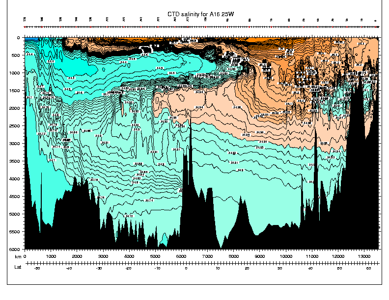
The most common thermal or salinity visuals show surface patterns. But more fascinating (I think) are meridional sections (because each follows a north-south line along a meridian). The meridians most often seen are the longest ones possible, unbroken by landmasses. For a picture of the salinity of the Pacific, at 150 degrees West (runs along the 150 degree longitude a little east of Hawaii – a relatively unobstructed cross-section from the Gulf of Alaska to the north coast of Antarctica) see: ftp://sam.ucsd.edu/pub/pac_sections/p16/plots/p16_sal.gif
For the Atlantic (25 degrees West – Greenland to Antarctica, via the Azores region) see: http://sam.ucsd.edu/sio210/gifimages/A16_CTDSAL.gif
For the Indian (95 degrees East – Bay of Bengal to Antarctica) see: ftp://sam.ucsd.edu/pub/ind_sections/i9/plots/I09_CTDSAL.gif
For a real mind-bender, check out a 3-D Schematic of Thermohaline Circulation by William Schmitz at http://gyre.ucsd.edu/sio210/nov5/schmitz_conveyor.jpg
There is an interesting, simplified, discussion of various factors of ocean layering at: http://www.sos.bangor.ac.uk/~oss041/des/o1p01/text/o1p01-06.htm An excerpt from this page is somewhat pertinent to the questions about the effect of melting in the polar regions:
<In the Pacific, . . . two tongues of lower salinity water are seen to sink and extend equatorwards from the subpolar regions. These are known as the Arctic and Antarctic Intermediate water masses. The latter is also visible in the Atlantic section. The spreading of these water masses is indicative of the thermohaline circulation, loosely speaking, that subsurface flow pattern produced by density differences not by wind forcing. >
Ben Pittenger
This archive was generated by hypermail 2.1.3 : Mon Aug 02 2004 - 12:05:37 PDT