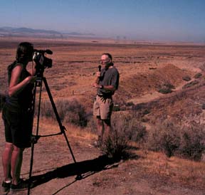
Sabrina videos Paul with Wallace creek in the background.
The creek flows in from the right, follows the San Andreas behind Paul, then jogs left to flow into the plain.
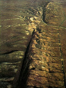
Offset Streams
The Carrizo Plains
For 30 years I have been looking in geology books at pictures of Wallace Creek, today I would get to see it for myself.
We drove across the flat Carrizo plains from West to East. The east side of the plains stopped at a short, 25 foot high (8m) cliff - a fault scarp - the San Andreas fault scarp. We spotted Jason's white van parked at the base of the scarp. Behind the van a stream bed did a strange thing. It flowed down a slope toward the valley as any gravity respecting stream would do. Then it abruptly jogged north for 100 yards (100m) and then jogged back to follow its course downhill. While it did its jog, it was following the San Andreas fault. The Pacific Ocean side of the fault had carried the downstream end of Wallace Creek with it as it moved north, creating the best example of an offset stream on Earth.
Geologist Charlie ?, had radiocarbon dated charcoal he found buried in the stream sediments. So now we know it took 3700 years for the San Andreas fault to move the stream 100 yards. The average motion of the fault was about 1.5 inches a year, 3 cm/yr, but the average hides the exciting story of motion along this fault. The fault doesn't creep along smoothly. For over a century it doesn't move at all, then within a second it jumps 30 feet, 10m. The last time this happened was during the Fort Tejon earthquake in 1857. Joanna, one of our BLM hosts, said that the Fort Tejon Earthquake was misnamed, she thought it should have been the Carrizo Plains earthquake, because the fault motion was obviously bigger here than in Fort Tejon. The problem in 1857 was that there were no reporters in the Carrizo plains to notice and write about the motion.
North of the Wallace Creek bed a shallow valley continued to flow north, it was a beheaded stream bed. 10,000 years ago Wallace Creek followed this course, but 3700 years ago the stream cut through its downhill bank carving a new path down onto the Carrizo plains, depriving the old stream valley of its stream. The old valley is over ten feet higher than the new one. Its elevation shows that, along this stretch, the San Andreas moves not only north-south but up-down as well.
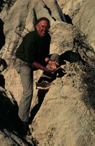
Left: Paul gathers rotten granite from a stretch of the San
Andreas along highway N2. The landscape looks like clay badlands, but
on closer inspection it looks like granite!
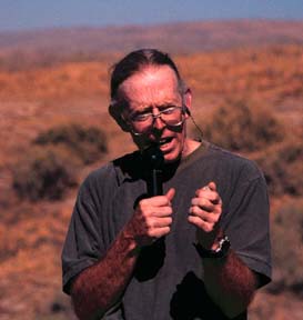
Right: Paul crumbles the granite in his fist in front of the webcast
audience.
Along the trace of the San Andreas granite has been fractured and chemically altered by diverted groundwater until pieces of it crumble when touched. That's why the trace of the San Andreas is often marked by a depression in the landscape. Erosion more easily removes the rock that has been ground up by motion along the fault. For the webcast program it was hard to find a piece of granite that was strong enough to survive the day-long trip to the Carrizo plains where I would try to crumble it with my bare hands.
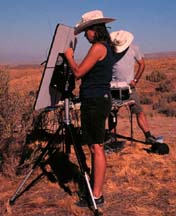
Behind the camera. Sabrina aims the satellite antenna toward the Pacific Ocean INMARSAT while Jason watches the monitor to help her make the optimum alignment. The INMARSAT communication box does all the spherical trigonometry necessary to tell you the bearing and elevation you need to point the antenna. The antenna comes with a compass and an inclinometer to help start the alignment process. Good alignment and a clear horizon are essential to making a good connection.
In the Carrizo Plains there is a spectacular air photo of a ridge, the Elkhorn scarp, pushed up by the fault, with a long gash right down the middle of its crest.
Sunset shadows exaggerate the Elkhorn scarp.
We wanted to take a picture of that gash. So we drove dirt roads completely circumnavigating the Elkhorn Scarp. At one point we took a side road that climbed steeply to the summit of the ridge. The road got so steep we had to abandon the cars and walk to the summit. We didn't find the gash, just a gentle line of depressed valleys. We hiked around and I found and photographed a beautiful set of shutter ridges, where mountain ridges are moved across the mouths of a creeks. But on the walk down I told Sabrina that our adventure reminded me of the scene in the movie Deliverance where Burt Reynolds is driving around looking for the Chatooga River. As he searches the back roads the locals comment, "It's only the biggest damn river in the whole state!" Here we were looking for the trace of the biggest fault in the whole state, it was surprisingly hard to find the traces of its presence.
At the end of the day we drove north toward Parkfield. We had started the day with offset streams, we were surprised to end the day with spectacular examples of offset streams as well.
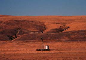
Just above the top of the windmill a faint light line runs across
the image. The line is the top of a ridge.
Behind the ridge is the San Andreas fault line. The streams flowing
down the hill behind the San Andreas have been blocked by the ridge.
The fault moved the ridge to the left, north. The streams flowed
along the fault then cut a new notch through the ridge. An excellent
example of an offset stream.
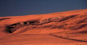
In the winter of 1995 storms caused the slump on the hillside above a stream offset by the San Andreas fault. The slump moved downhill into the stream valley and clogged the mouth of the stream where it had carved an exit "V" in the blocking ridge.
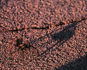
Fall is the time when a young tarantulas thoughts turn to love! Here is one taking a sunset walk along the sun warmed road to Parkfield.
Visit the Exploratorium web pages for more information on faults:
Go to the Exploratorium Faultline site
|
Scientific Explorations with Paul Doherty |
|
11 Oct 99 |