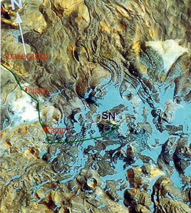
The route to the summit.
The Route
By studying maps and space photos I picked out a route before we left for Chile. As we climbed the mountain we favored two other routes, but in the end followed the route of our original plan.
The route to the summit.
We drove from El Salvador passed the refinery town of Potrerillos to the water supply tanque of La Ola. Beyond La Ola we pulled off the road to follow the Rio Juncal. And I do mean follow the river. We drove in the river for quite a ways. About 2 kilometers below the Juncalito hot springs or "thermas" we climbed out of the river canyon following a steep sandy road up to a plateau.
We all jumped out of the car to push it up the steep soft sand. Struggling uphill through the loose sand driving more like boats than cars, the wheels of the cars came very near to the edge of the road, if they had gone over the would have rolled over for a hundred feet down to the river.
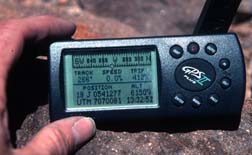
At the top Maxi asked us to mark the location of the exit road from the plateau on our GPS's. It was Pancho's first time on this road and if we missed the correct descent gully on the way home we would be in big trouble. Maxi himself had set up a pole to mark the correct road, but it would be our job to find the pole. We had all set our GPSs to the Provisional South American map datum, the reference datum used by the maps we were using.
We drove across the featureless plateau, crossed by many different sets of tire tracks going in all directions. I put in several other waypoints to mark the route. We drove past Salar Pedernales then down to the base of Quebrada Arenal our route to the mountain. I was shocked when Maxi turned to me and said you can navigate now. I frantically grabbed my maps and GPS and guided the final approach to the highest point the trucks could reach in the quebrada.
We set up a pre-basecamp, then the next day managed to move a kilometer more up the quebrada to the point where it became narrow and choked with rocks. Here we set up base camp at 4500m. At basecamp there was the truck, Pancho's tent, and Tony's Oval 25 tent.(UTM 19J 0533482, 7076340)
From basecamp we followed "The great white way," Quebrada Arenal. The quebrada was full of white rocks. The sides of the quebrada were much darker rock. Near the top, the quebrada steepened then crossed onto a flat plateau. Here was camp1, at 5200 m.(UTM 19J 0536408, 7073737)
Above camp 1 was a great bowl of colorful sediments , the "National Monument." We ascended a ramp just to the left, east of the National Monument to another plateau. This plateau even had a small pond on it. We then crossed back to the right climbing above the left edge of the national monument into an area that smelled of sulfur. We crossed on a flat area to the west and east of a high summit then eventually curved around to the south of that summit setting up camp 2 just before a jumbled maze of lava and ice at 5555m.(UTM 19J 538005, 7070092)
From camp 2 we descended a little to a short canyon that lead us into the maze. We hiked into the canyon then up its headwall where we gained our first view of the summit. We wove our way around lava cliffs and ice fields to reach the base of the west face of the mountain. Here a ramp lead up and left curving up high onto the south ridge. We then followed the south ridge to the summit.(UTM 19J 0541277, 7070081)
There were two summits at nearly the same height, we built cairns on both of them.