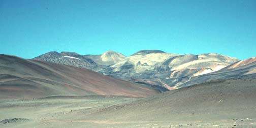
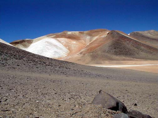
The complex summits of Sierra Nevada de Lagunas Bravas.
The highest summit is the one just left of the black topped mesa.
The snowy mountain of the wild lakes.
Bob Ayers found it.
An unclimbed mountain!
John Biggar, in "The Andes, A guide for Climbers" said that three of the 99 summits over 6000 meters have no recorded ascents including a peak named Sierra Nevada.
In 1998, Bob and I saw Sierra Nevada from the summit crater of Ojos del Salado.
So, when Bob invited me to go climb the peak with him, I signed up immediately. I have been climbing mountains for over 30 years and reading mountaineering literature even longer, yet I had never done a first ascent. I thought I had the necessary skills, now it was time to find out.
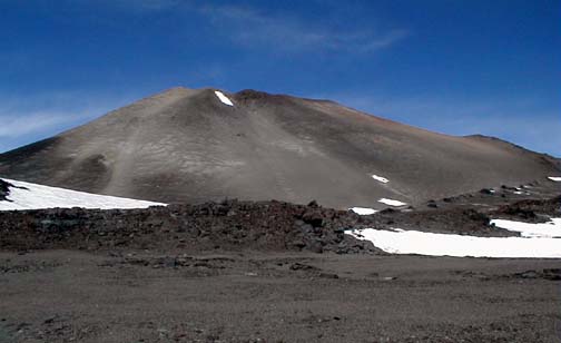
The peak we chose was a complex volcano on the Chile-Argentina Border named Sierra Nevada de Lagunas Bravas. It is 6127 meters high, (20,100 feet). There was no record of anyone ever having climbed it, yet it was near enough to Paso de San Francisco, the trans-andean route of the Inca empire that it was possible we might find that the Inca had been there before us. Many first ascent parties in the Andes have been surprised on the summits of high mountains like Llullillaco to find stone houses and shelters built by indians 500 years before. Perhaps we would too.
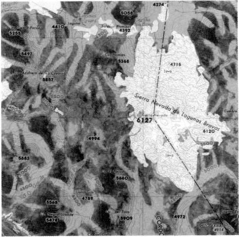
Bob bought a map of the mountain from the IGM, the mapping survey of Chile. It had a scale of 1/250,000 and was not very useful for planning a route, but it was a start.
There were no photographs of the mountain! However, I did find a web page on Andean Volcanos which included an air photo and a space image. The page said that Sierra Nevada was in "the most remote and inaccessible part of the central Andes," which probably explained why it had never been climbed.
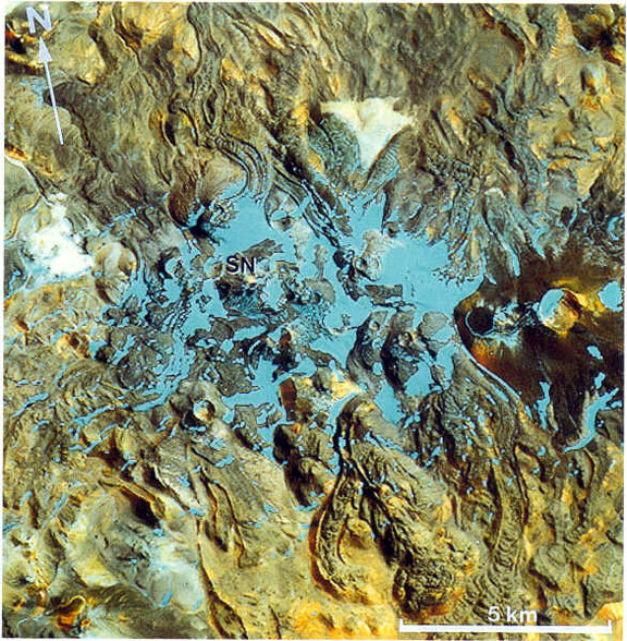
Staring at the image I could see lava flows, ice fields and strange regions of light and dark soil. Finding a route through the complicated maze of lava and ice was definitely going to be an adventure.
In 1998 we hired Maximiliano Martinez and his company, Aventurismo, to search out an off road route to the mountain. Maximiliano and his son Sebastian drove two, four-wheel drive vehicles in to the base of Sierra Nevada and gave Bob pictures of their trip. They had managed to drive through some beautiful wild Atacama desert country to reach our proposed base camp northwest of the summit at the bottom of Quebrada Arenal.
In the year of preparation leading up to the climb we added two more members to our party: Paul Morgan and Tony Brake. I've been climbing with Paul for over 20 years. Tony was a new acquaintance, but Paul spoke highly of him, they shared an open bivy ledge on Mount Kenya and came away friends, high praise indeed.
We also used the year of preparation to get a permit from the Chilean Ministry of Frontiers and Limits You must get a permit to climb a mountain on the border. It takes three months to get the permit, when it arrived we celebrated.
The mountain is also known as Sierra Nevada (Puna). Our spanish dictionary translated the sspanish word puna into the english word "Puna." Big help! However we later found that Puna is the proper name for a large region of the Atacama desert. A second dictionary told us puna had taken on two meanings: a "high bleak plateau" and "difficulty in breathing." The mountain we were going to climb rose 6,000 feet above the plateau. We would certainly get to see plenty of "puna" on our trip.
Click on the images to see enlargements.
We met Maxi and Pancho at Hotel del Inca
in El Salvador. Maxi and Pancho were full of good humor,
I was looking forward to driving with them across the
desert. We had just come from the market where we
entertained the other shoppers with our purchases of peanut
butter and other exotic foods. After meeting Maxi we drove to the market
and purchased 80 liters of water, one human body weight.
This would give 4 of us enough water for 5 days at base
camp. Higher up the mountain we planned to melt ice for
water. Maxi brought us 5 liters of Bencina
Blanca for our stove.
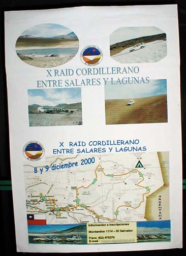
Inside the hotel we saw a poster for the
tenth off road ride across the desert "X Raid." 40 vehicles
were going to circle around the desert, passing near our
basecamp. It was comforting to think that if we got
really stuck in the desert a caravan would rescue
us. We drank in the pictures of the salars,
or salt pans, desert and lakes. We were glad that we were going in to
base camp in a convoy of two vehicles, if one got stuck the
other could rescue it. Pancho would stay at basecamp with
one vehicle while Maxi drove home. Pancho was a top mountaineer, we invited
him to join us on our climb, however he showed us his
recently sprained ankle and declined our invitation. He was
looking forward to recovering at base camp. We drove inland and uphill past the
refinery at Potrerillos, the town where Pancho was born and
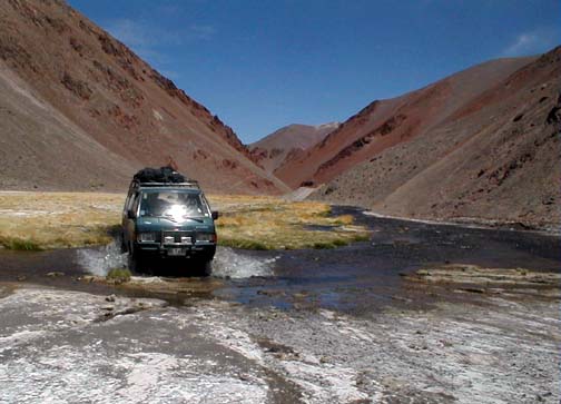
Maxi had been school principal. We left the road near the watering hole
of La Ola driving beside the Rio Juncal. When we left the
road Maxi joked that soon we would be driving in the
river! He wasn't joking. Driving in the river
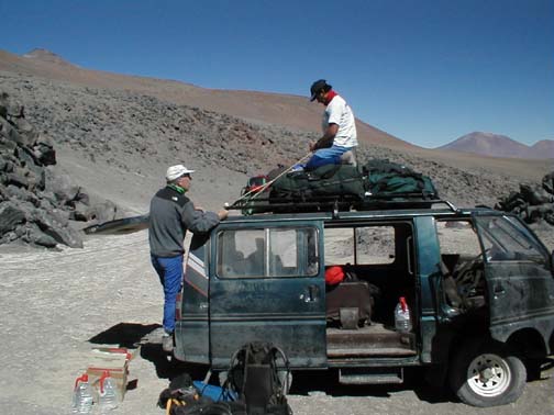
provided access to the deep desert. Maxi's 4 wheel drive van carried our team
and its gear. The way was rough and we were glad for the
large number of handles we could grab to hold ourselves
inside the vehicle. The water in the river is sweet and
drinkable. After several bouts of abandoning our
seats to push the cars through deep soft sand we arrived at
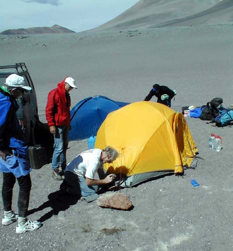
basecamp. The wind was blowing so we anchored our
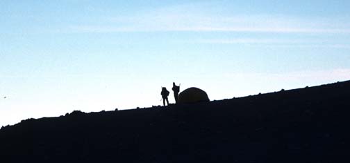
tents well. Tony put up his North Face Oval 25 tent
as the basecamp tent. Pancho had his own 1 man tent.
For the mountain we brought a Bob's 4 man
Himalayan Hotel. Only 2 could sleep in Tony's tent but all
of us could fit inside for dinner and breakfast. At bedtime, Bob and I spread our
groundcloths on the desert and slipped into our sleeping
bags. The southern stars were phenomenal. I
enjoyed watching the clouds of Magellan, the coal sack near
the southern cross and much more.
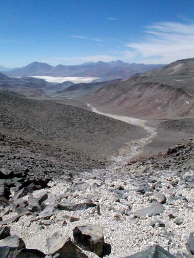
The route from Basecamp to camp 1 was up
Quebrada Arenal. Here is the view from camp 1 down Quebrada
Arenal to basecamp. The Quebrada was a dry wash floored with
white stones, I called it "the great white way." Basecamp was at 14,800 feet, higher than
the summit of Mount Whitney. Camp 1 was at 17,000 feet. Camp
2 at 18,000 feet and the summit at 20,100 feet, nearly as
high as the summit of Mount McKinley. Hiking up the Quebrada we saw tracks of
vicuna. We also saw occasional small clumps of grass It was
hard to believe that any animals could survive on such
meager food. Above camp 1 was a spectacularly
beautiful amphitheater. A thousand foot high bowl of white
cream and tan streaked rocks. It was so neat that in the US
it would have been a National Monument. This bowl was the
source of the white rocks i the quebrada. Our topographic maps showed that the
white bowl was a glacier. We planned camp 1 at its base to
harvest the ice to make drinking water. The map was wrong,
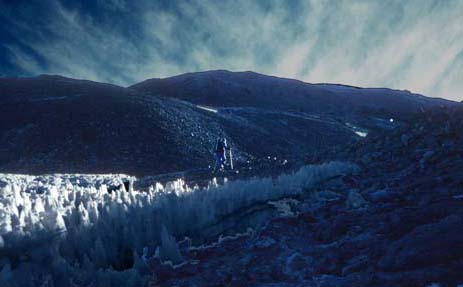
the white was sand, clay and rock. Luckily, near camp 1 there was a small
field of neve penetentes. Paul Morgan and I harvested several
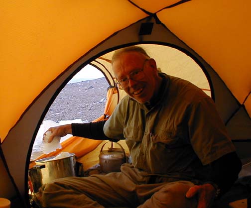
plastic bag fulls of ice to melt for water. Then, while Tony and Paul set up camp and
melted ice, Bob and I went ahead to scout a route to camp 2.
We started up into the slot between split Dome and Black
Mesa where we could see a snow field for water along what we
thought would be the shortest route to the summit. But rough
lava flows made the going difficult so we headed west
crossing over the top of the "National Monument."
There we found a flat spot for camp 2
together with more ice for water. When we arrived at the spot we had chosen
for camp 2, we realized that we might be able to push up a
little higher. Paul M and I explored ahead and found an
advanced site for camp 2. It was right at the base of the
massive maze of lava flows and ice that separated us from
the summit. We moved up to the new site, set up the
Himalayan Hotel and started to melt ice to make water for
dinner and for tomorrow's summit bid. We still could not see the summit and
wondered what difficulties tomorrow would bring. A cold wind blew all night and in the
morning it was very cold outside the tent (-15 C). Luckily
the body heat from four of us kept the tent warm. Before the sun hit the tent, we put on
our down parkas covered them with goretex wind stoping
layers, put on gloves and hats and stepped out into the cold
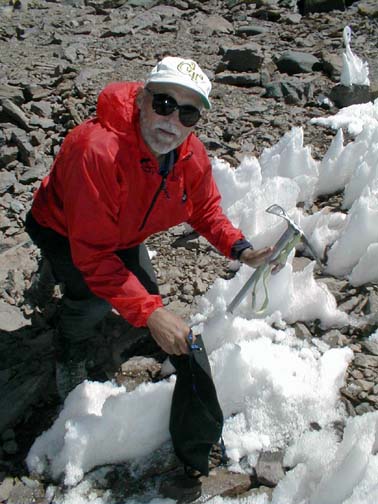
clear air ready to find a route to the summit. Bob Ayers hiking through the maze of
black lava and stark white ice. When we climbed the first lava flows all
we could see were more lava flows. Between the lava flows were un-moving
deposits of snow and ice, not glaciers. These were awful to
cross, this year's rotten layer of foot high neve penetentes
lay on last years solid ice four foot layer of ice blades.
Nasty. Mostly we hiked on the loose lava flows.
After wandering through the maze with
invaluable guidance from our GPS systems we climbed up onto
a lava flow and got our first view of our goal. It was beautiful, we could see a route to
the summit immediately. Our spirits rose, now all we had to do
was to follow our spirits with our bodies. We climbed a ramp diagonalling up and
right to the south ridge, the right skyline in this photo,
then followed the ridge to the summit. Bob was the first one to step onto thetop
of the south ridge. The wind was picking up, shredding the
clouds behind him. We walked uphill. Trying to find the
firmest footing in the loose scree that coated the mountain.
I used the mountaineers rest step breathing once for every
footfall.
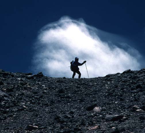
As we climbed a cold wind began to grow
as it does most afternoons in this region of the Andes. We
donned our goretex shells again, plus hats and gloves and
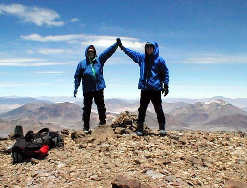
pushed on upwards toward the summit. Bob was the first one on the summit. As
was only fitting since this whole trip was his idea. He
greeted us by saying he had bad news and great
news. The bad news was that there was a cairn
on the summit. The very good news was that he had built
it! We were the first ones to climb Sierra
Nevada de lagunas Bravas. Our whole team made the summit. We
spent an hour on top savoring the climb. We returned to camp 2 for the night.
Tired and happy. The next day we packed down from camp 2,
stopping by camp 1 to pick up even more gear, then with
heavy loads made our way back to base camp where Pancho
greeted us with high fives and handshakes when he learned of
our success. We slept one more night at basecamp. Got
up and packed the truck which wasn't as clean as it was
before. Then departed for the "fleshpots" of
Copiapo. Actually what we wanted most was a shower
and a place out of the wind in which to smell flowers and
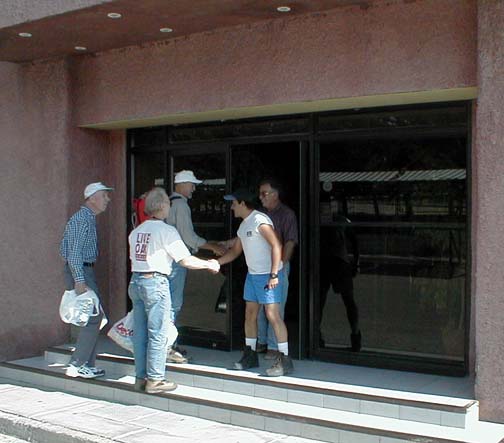
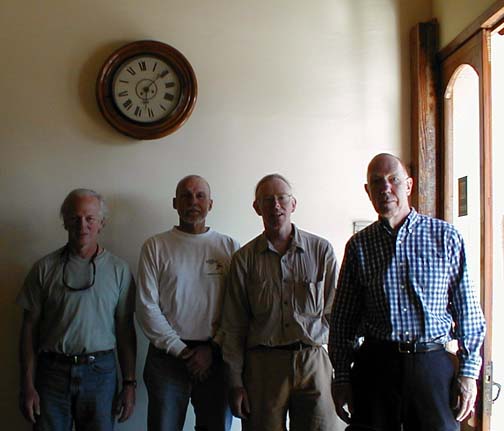
drink wine. After the mountain, the team gathers in
the lobby of Hotel La Casona in Copiapo. Washed, fed, rested and ready for another
first ascent...after all, there are still two unclimbed
Andean summits waiting for us. Bob asked, "where are all the old time
climbers rushing to snap up the unclimbed peaks of the
world?" I looked at him and answered, "Bob, WE ARE the old
climbers."
Here are more details of our trip.
Assembling the Team: Just like in the movies begin by meeting the team and learning how they get ready.
Short Stories: vignettes from the mountain.
The Route: Including GPS waypoint coordinates.
Gear List, what I brought
|
Scientific Explorations with Paul Doherty |
|
21 Nov 2000 |