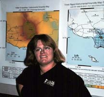
Lucy Jones, the red colored trinet map behind her shows the region of Northridge where accelerations near 1g occurred.
Cal Tech, Tom Humphrey, the other Senior Staff scientist is an alum here. He should do this show!
But with a ponytail, some gray hair, a backpack, and a black notebook I look just eccentric enough to be a physics professor. So, while searching for the faultline crew, I wander through a few buildings: astronomy had good photos on the walls, and geology had good maps, geophysics was my goal and it had everything, photos, maps, and displays. Old fashioned seismographs were running in the hallway, their pens writing the motion of the earth onto drums of paper.
The crew was on the second floor, in the official media room. Jason had run the cables out the window and up onto the roof to the INMARSAT transceiver. He said it reminded him of Zane's stories of the OJ trial where fat bundles of cables ran out of windows to satellite dishes above. This was no OJ trial however and only 3 thin cables snaked their way out and up.
Before the show I welcomed our guest Lucy Jones from the USGS Trinet project. She was director of a program that was placing hundreds of seismometers and data loggers all over southern California.
I was most impressed by the first seismometer she brought with her. It was a legendary Wood-Anderson seismometer. The very instrument that defines the Richter scale.
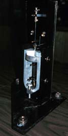
The Richter magnitude of a quake is:
the base 10 logarithm of
the maximum displacement in micrometers,
of the line produced by a Wood-Anderson seismograph,
located 100 km from the epicenter of an earthquake.
Whew!
Lucy pointed out that since there are no working Wood-Anderson seismographs in existence, that there are no longer any true measurements of the Richter magnitude! Geologists use instead the moment magnitude scale. The Richter scale measured a complicated mix of the ground motion and its acceleration, the moment magnitude attempts instead to measure the energy of the quake. The moment magnitude is also a logarithmic scale. An increase of one unit on the moment magnitude scale corresponds to an increase in the energy released by the quake by a factor of about 30. (Actually closer to 33.)
Engineers use another scale, the surface wave magnitude. It measures the maximum motion of the surface of the ground due to lower frequency surface waves from the earthquake. It is adjusted to match the Richter scale for quakes of magnitude 6 and under. However, Lucy said that over magnitude 6 the scales begin to diverge. Nowadays, the earthquake magnitude reported by the southern California earthquake center is the surface wave magnitude.
My friend Hal has an interesting story. After the Loma Prieta Earthquake he headed down to the USGS in Menlo Park where they had a seismogram on their wall. The recording line went from one side of the paper to the other and banged into the edges of the paper. "Why didn't you use the less sensitive strong motion seismogram in your display," he asked. They replied, "That IS the strong motion seismogram!"
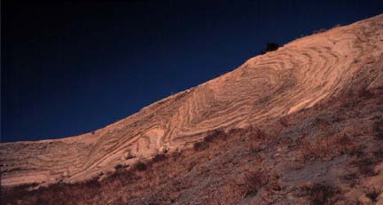
Life on the road has its adventures. After the broadcast, we drove to Palmdale then followed the San Andreas through brand new housing developments right on the fault, past granite that had been pulverized by the fault, to the Carrizo plains.
There was one funky hotel in the town of California Valley the only town in the Carrizo plains but they "didn't have any rooms that were cleaned up." So we took the hint and headed out to find a campground. We drove into the Los Padres National forest along a road that got smaller and smaller. The middle line went away first, then the pavement, then the dirt road got smaller and the ruts got bigger. We drove on for miles. Big black gaps in the road showed where it had been eaten away by creeks. At 9 PM we arrived at the campground. We were hungry and tired, but a sign at the campground made us feel great. It said, "Please don't feed the Condors."
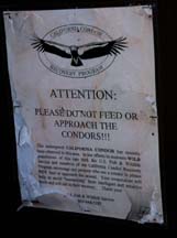
Any campground that has Condors for camp robbers is a high class place in my book and Ellen's too. We laughed at the sign, ate dinner and went to bed in out Van. We got a good nights sleep too.
Visit the Exploratorium web pages for more information on faults:
Go to the Exploratorium Faultline site.
|
Scientific Explorations with Paul Doherty |
|
11 Oct 99 |